The Threat of Environmental Hazards to the Rental Stock

About 40 percent of the nation’s occupied rental stock, representing 17.6 million units, are located in areas that will experience substantial annual losses from increasingly common environmental hazards, according to analysis in the Center’s America’s Rental Housing 2022 report. Environmental hazards like wildfires, flooding, earthquakes, and hurricanes jeopardize the health and safety of renters and threaten to damage or destroy rental units. This analysis pairs housing data from the American Community Survey with data on environmental risk from the Federal Emergency Management Agency’s National Risk Index to assess the exposure of rental housing to these hazards.
The Federal Emergency Management Agency’s (FEMA) National Risk Index measures hazard risk using an Expected Annual Loss component. Expected Annual Loss represents the average economic loss in dollars resulting from hazard events each year and is based on the impact of 18 environmental hazards on people, buildings, and agriculture. FEMA assigns each census tract an Expected Annual Loss rating ranging from Very Low to Very High based on the anticipated frequency and severity of different hazards, and the percentage of the population, building value, and agricultural land expected to be lost.
Areas with substantial expected annual losses are geographically widespread, reflecting the variety of acute and chronic environmental hazards that impact every part of the country. Figure 1 shows the number of rental units in each county that are located in a census tract with at least moderate expected annual losses. Many of the hotspots are on the West Coast, where wildfires pose an outsized risk to renters and their homes, while others are clustered along the Gulf Coast, where hurricanes and coastal flooding are common.
Figure 1: More Than 17 Million Rental Units Are Under Threat from Environmental Hazards
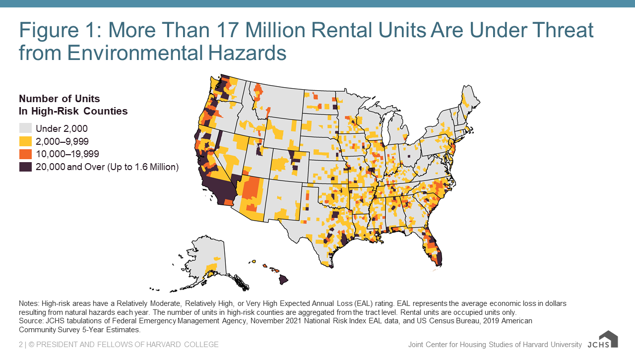
Notes: High-risk areas have a Relatively Moderate, Relatively High, or Very High Expected Annual Loss (EAL) rating. EAL represents the average economic loss in dollars resulting from natural hazards each year. The number of units in high-risk counties are aggregated from the tract level. Rental units are occupied units only.
Source: JCHS tabulations of Federal Emergency Management Agency, November 2021 National Risk Index EAL data, and US Census Bureau, 2019 American Community Survey 5-Year Estimates.
The states with the most rental units at risk are generally located in the West and South (Figure 2). California has the largest number of rental units at risk, with 4.5 million rentals (76 percent of the state’s occupied rental stock) located in census tracts with at least moderate expected annual losses due to likely hazards. Of these units, 1.6 million are located in areas with Relatively High or Very High expected annual loss ratings. Washington and Oregon also have significant numbers of rentals in areas with at least moderate expected annual losses, with around 85 percent of the occupied rental stock in each state located in such areas. Other states with particularly large numbers of rental units at risk include states in the South and along the Gulf Coast, including Texas (2.3 million units in areas with at least moderate losses), Florida (940,000), North Carolina (570,000), Tennessee (540,00), Louisiana (470,000), and Georgia (460,000).
Figure 2: The States With The Most Rental Units at Risk due to Environmental Hazards Are Located in the West and South
| State |
Number of Units In High-Risk Areas (Thousands) |
Number of Units In Very High-Risk Areas (Thousands) | Share of Units In High-Risk Areas (Thousands) |
|---|---|---|---|
| California | 4,480 | 1,590 | 76% |
| Texas | 2,290 | 1,040 | 62% |
| Florida | 940 | 240 | 35% |
| Washington | 900 | 680 | 85% |
| Missouri | 630 | 180 | 78% |
| North Carolina | 570 | 190 | 41% |
| Tennessee | 540 | 130 | 61% |
| Oregon | 520 | 130 | 85% |
| Louisiana | 470 | 260 | 79% |
| Georgia | 460 | 40 | 33% |
Notes: High-risk areas have a Relatively Moderate, Relatively High, or Very High Expected Annual Loss (EAL) rating. Very high-risk areas have a Relatively High or Very High Expected Annual Loss (EAL) rating. EAL represents the average economic loss in dollars resulting from natural hazards each year. The number of units in high-risk counties are aggregated from the tract level. Rental units are occupied units only.
Source: JCHS tabulations of Federal Emergency Management Agency, November 2021 National Risk Index EAL data, and US Census Bureau, 2019 American Community Survey 5-Year Estimates.
Nationally, single-family rentals and manufactured rentals are the most likely to be exposed (Figure 3). 6.6 million occupied single-family rentals are in census tracts with at least moderate expected annual losses. An additional 2.6 million units in 2-4-unit multifamily buildings are at risk, as are 3.8 million units in multifamily buildings with 5-19 units and 3.5 million units in large multifamily buildings with 20 or more units. While manufactured housing units represent a small share of the rental stock and just 1.1 million of the units in high-loss areas, they are the most likely of any structure type to be at risk, with 56 percent of manufactured rentals located in high-risk areas. Manufactured units are also more likely to be classified as structurally inadequate by HUD than other types of rental units, and therefore may be especially vulnerable to loss due to hazards.
Figure 3: Environmental Hazards Pose Outsized Risk to Single-Family Rentals and Manufactured Housing Units
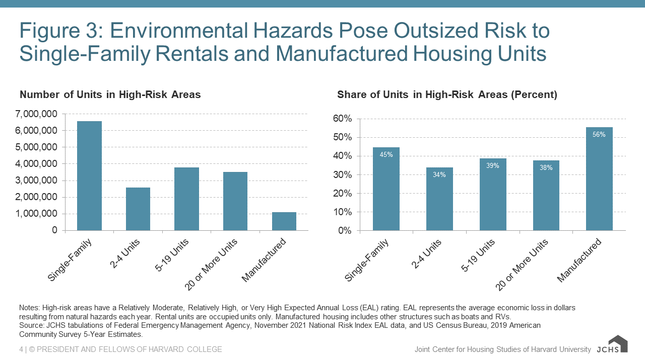
Notes: High-risk areas have a Relatively Moderate, Relatively High, or Very High Expected Annual Loss (EAL) rating. EAL represents the average economic loss in dollars resulting from natural hazards each year. Rental units are occupied units only. Manufactured housing includes other structures such as boats and RVs.
Source: JCHS tabulations of Federal Emergency Management Agency, November 2021 National Risk Index EAL data, and US Census Bureau, 2019 American Community Survey 5-Year Estimates.
Many of the units at risk are low-rent or subsidized (Figure 4). 4.0 million occupied units with contract rents below $600, representing 40 percent of those rentals, are located in areas with at least moderate expected annual losses due to environmental hazards. As noted in America’s Rental Housing 2022, both the number and share of units renting for less than $600 have been on the decline in the past decade. With the supply of low-rent units already shrinking, massive losses of this stock from environmental hazards would leave lower-income households with even fewer affordable rental options.
Figure 4: Millions of Low-Rent and Subsidized Rental Units Are at Risk Due to Environmental Hazards
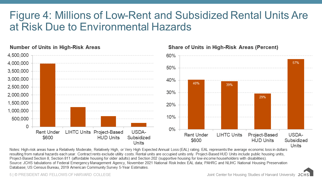
Notes: High-risk areas have a Relatively Moderate, Relatively High, or Very High Expected Annual Loss (EAL) rating. EAL represents the average economic loss in dollars resulting from natural hazards each year. Contract rents exclude utility costs. Rental units are occupied units only. Project-Based HUD Units include public housing units, Project-Based Section 8, Section 811 (affordable housing for older adults) and Section 202 (supportive housing for low-income householders with disabilities).
Source: JCHS tabulations of Federal Emergency Management Agency, November 2021 National Risk Index EAL data; PAHRC and NLIHC National Housing Preservation Database; US Census Bureau, 2019 American Community Survey 5-Year Estimates.
In addition, more than 2.1 million subsidized units are located in high-risk areas. Of the 3.1 million units created under the Low-Income Housing Tax Credit (LIHTC) program, 1.2 million, or 39 percent of all LIHTC units, are located in areas with at least moderate expected annual losses. Also at risk are 700,000 of the nation’s 2.3 million project-based HUD units, which include public housing units, Project-Based Section 8 units, affordable housing for older adults, and supportive housing for low-income householders with disabilities. In addition, 230,000 units in the USDA-subsidized stock, a rural multifamily housing program with over 400,000 units, are located in these high-risk areas. The subsidized stock already faces a host of preservation issues, which will be compounded by their exposure to future, almost certain hazards.
An increasing number of rental units will be at risk of loss due to environmental hazards in coming years. In the short term, damage from hazards will almost certainly drive up the cost of repairing and rebuilding rental units. Reducing the time to build replacement rental housing after a natural disaster and increasing the availability of post-disaster financial assistance for renters are both urgent priorities. At the same time, the growing frequency and severity of hazards and the magnitude of their damages will likely make an increasing number of rental units uninhabitable, displacing residents and threatening to further reduce the supply of rental housing. A massive federal and local investment is needed to preserve the existing stock and adapt rental units to the wide range of acute and chronic environmental hazards exacerbated by global climate change.


